


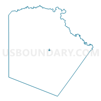
Voting District 4006, Bexar County, Texas
About
Outline

Summary
| Unique Area Identifier | 670540 |
| Name | Voting District 4006 |
| County | Bexar County |
| State | Texas |
| Area (square miles) | 0.32 |
| Land Area (square miles) | 0.32 |
| Water Area (square miles) | 0.00 |
| % of Land Area | 100.00 |
| % of Water Area | 0.00 |
| Latitude of the Internal Point | 29.44315770 |
| Longtitude of the Internal Point | -98.47379080 |
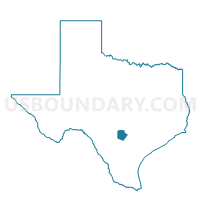
Maps

Graphs
Select a template below for downloading or customizing gragh for Voting District 4006, Bexar County, Texas


Neighbors
Neighoring Voting District (by Name) Neighboring Voting District on the Map
- Voting District 2035, Bexar County, TX
- Voting District 2130, Bexar County, TX
- Voting District 4001, Bexar County, TX
- Voting District 4007, Bexar County, TX
- Voting District 4119, Bexar County, TX
- Voting District 4122, Bexar County, TX
- Voting District 4123, Bexar County, TX
Top 10 Neighboring County Subdivision (by Population) Neighboring County Subdivision on the Map
Top 10 Neighboring Place (by Population) Neighboring Place on the Map
Top 10 Neighboring Unified School District (by Population) Neighboring Unified School District on the Map
- San Antonio Independent School District, TX (307,591)
- Fort Sam Houston Independent School District, TX (7,129)
Top 10 Neighboring State Legislative District Lower Chamber (by Population) Neighboring State Legislative District Lower Chamber on the Map
Top 10 Neighboring State Legislative District Upper Chamber (by Population) Neighboring State Legislative District Upper Chamber on the Map
Top 10 Neighboring 111th Congressional District (by Population) Neighboring 111th Congressional District on the Map
Top 10 Neighboring Census Tract (by Population) Neighboring Census Tract on the Map
- Census Tract 1201, Bexar County, TX (7,129)
- Census Tract 1920, Bexar County, TX (5,244)
- Census Tract 1110, Bexar County, TX (2,125)
- Census Tract 1109, Bexar County, TX (549)